Could an unusual summer El Niño mean cooler temps in Illinois? See forecast
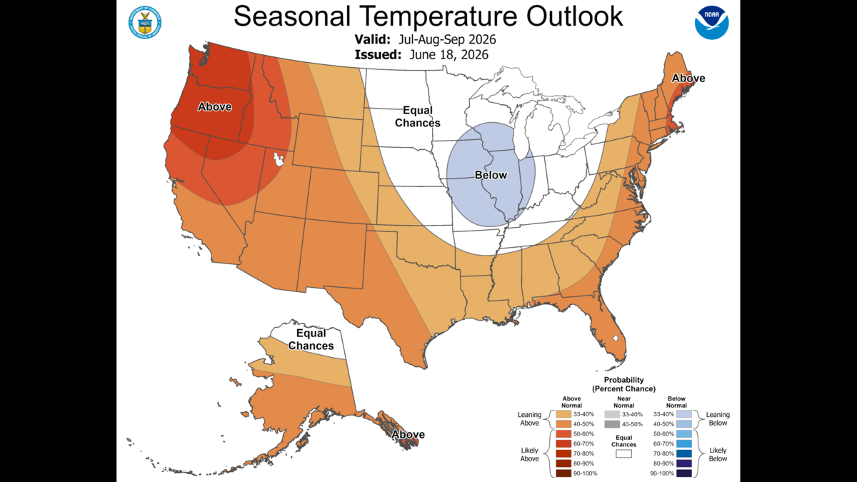
An uncommon midsummer El Niño pattern has recently emerged, and its effects in Illinois and surrounding areas are expected to vary from the rest of the nation.
While the western, south and northeast regions of the U.S. are expected to see above-average temperatures from July through September, Illinois, most of Missouri and slivers of surrounding states are favored for below-normal temperatures in the Climate Prediction Center’s three-month seasonal outlook.
With a 33 to 40% chance of below-normal temperatures in Illinois, there’s still some uncertainty, but it’s a significant variance from the West Coast’s 60 to 70% chance of warmer temperatures.
“From a seasonal perspective, I believe a lot of what’s driving that actually is El Niño,” Jayson Gosselin, meteorologist with the NWS St. Louis office, told the News-Democrat Tuesday.
The terms El Niño and La Niña refer to climate patterns determined by tradewinds and water temperatures. El Niño occurs when tradewinds are weakened and warm water is pushed east, the National Oceanic and Atmospheric Administration reports, while La Niña has the opposite effect.
“There’s not that many cases where we have a well-defined El Niño in the middle of summer. It just historically doesn’t happen very often,” Gosselin said. “Historically speaking, those El Niños that have happened in the summer tend to have a little bit cooler-than-normal temperatures for this part of the country.”
The El Niño pattern, which developed in early- to mid-June, is expected to strengthen at least through late fall and likely into early winter. Forecasters report there’s a 63% chance the event will become a “very strong” El Niño.
A “very strong” El Niño in the forecast means sea surface temperatures in the Pacific Ocean near the Equator are expected to be 3.5 degrees Fahrenheit warmer-than-normal, Gosselin said.
How could a strong El Niño affect Illinois’ winter?
A strong or very strong El Niño pattern is likely to peak sometime between November and January, Gosselin said.
There’s a lot of variability in El Niño’s effects on winter weather, Gosselin said, but the average El Niño winter brings slightly below-normal precipitation to the Illinois and St. Louis area, despite a couple of outliers.
El Niño typically brings warmer-than-normal winter conditions to the northern plains, upper Midwest and Great Lakes area, Gosselin said, and colder-than-normal temperatures to the Gulf Coast.
“But again, there’s a lot of variability year-to-year in terms of temperature, precipitation and snowfall,” Gosselin said.
The impacts of El Niño in the wintertime are generally stronger in other parts of the country compared to the Illinois and Missouri area, Gosselin said.
Do you have a question about the weather or the environment in Illinois for the News-Democrat? We’d like to hear from you. Fill out our Metro-east Matters form below.